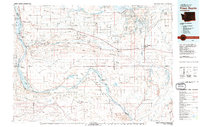
1979 Map of Priest Rapids
USGS Topo · Published 1979About this map
The Columbia River carves a dramatic path through this 1979 landscape, flanked by the Saddle Mountains and the expansive Hanford Works area to the south. This era shows a region defined by large-scale water management and restricted federal lands, with the Wanapum Dam and Priest Rapids Dam controlling the river's flow. Between the ridges of the Frenchman Hills and the Wahluke Slope, the map reveals a network of irrigation-driven agriculture evidenced by the Saddle Mountain Wasteway and Frenchman Hills Wasteway.
Find a feature on this map
114 named features on this map. Tap any name to fly to it.
Don’t see what you’re looking for? This feature index may not catch every label — zoom into the map to look around manually.
Map Details
Editions of this 1979 Priest Rapids Map
2 editions found
Other maps of this area

1909 · Quincy
USGS Topo · 1:62,500

1910 · Zillah
USGS Topo · 1:125,000

1910 · Quincy
USGS Topo · 1:62,500

1910 · Winchester
USGS Topo · 1:62,500

1911 · Red Rock
USGS Topo · 1:62,500

1912 · Moses Lake
USGS Topo · 1:62,500

1912 · Beverly
USGS Topo · 1:62,500

1915 · Wallulah
USGS Topo · 1:96,000

1915 · Prosser
USGS Topo · 1:125,000

1916 · Connell
USGS Topo · 1:125,000