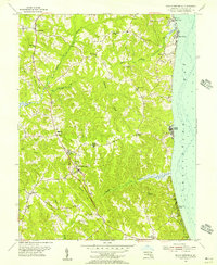
1953 Map of Prince Frederick
USGS Topo · Published 1956About this map
Prince Frederick serves as the focal point of this mid-century Calvert County landscape, situated atop the ridge between the Patuxent River and the Chesapeake Bay. The 1953 survey captures a rural Maryland peninsula defined by its social infrastructure, featuring numerous community landmarks such as St Pauls Ch, Wesley Ch, and the County Hospital. Educational centers like Brooks High Sch and Plum Point Sch are scattered across the interior, connected by a network of winding roads that follow the high ground between deeply incised drainage systems like Hunting Creek and Parker Creek. Along the eastern shoreline, established waterfront communities such as Dares Beach and the distinctive Scientists Cliffs demonstrate the era's coastal residential patterns. This map offers a clear view of the county seat's layout before later suburban expansion, preserving the locations of family-named cemeteries like Asberry Cem and Calvary Cem.
Find a feature on this map
41 named features on this map. Tap any name to fly to it.
Don’t see what you’re looking for? This feature index may not catch every label — zoom into the map to look around manually.
Map Details
Editions of this 1953 Prince Frederick Map
4 editions found
Other maps of this area

1892 · Leonardtown
USGS Topo · 1:62,500

1892 · Drum Point
USGS Topo · 1:62,500

1892 · Prince Frederick
USGS Topo · 1:62,500

1893 · Sharps Island
USGS Topo · 1:62,500

1895 · Prince Frederick
USGS Topo · 1:62,500

1895 · Leonardtown
USGS Topo · 1:62,500

1895 · Nomini
USGS Topo · 1:125,000

1898 · Choptank
USGS Topo · 1:125,000

1898 · Nomini
USGS Topo · 1:125,000

1898 · St. Marys
USGS Topo · 1:125,000
Featured Places
- Prince Frederick, MD
- Hidden Valley, MD
- Chesapeake Heights on the Bay, MD
- Huntingfields Manor, MD
- Poplar Woods, MD