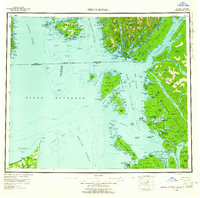
1959 Map of Prince Rupert
USGS Topo · Published 1961About this map
Prince Rupert serves as the focal point for this late-1950s maritime study of the northern Pacific coast, where the international boundary between Alaska and British Columbia threads through the Dixon Entrance. The map details the complex industrial and indigenous geography of the Tsimpsean Peninsula, featuring established settlements like Metlakatla and Port Simpson. This era represents a period of significant coastal commerce, evidenced by the cluster of canneries and processing centers at Port Edward, North Pacific, and Haysport along the Skeena River.
Find a feature on this map
114 named features on this map. Tap any name to fly to it.
Don’t see what you’re looking for? This feature index may not catch every label — zoom into the map to look around manually.
Map Details
Editions of this 1959 Prince Rupert Map
5 editions found

Other maps of this area

1948 · Prince Rupert D-6
USGS Topo · 1:63,360

1948 · Dixon Entrance C-1
USGS Topo · 1:63,360

1948 · Ketchikan A-6
USGS Topo · 1:63,360

1948 · Craig A-1
USGS Topo · 1:63,360

1948 · Dixon Entrance D-1
USGS Topo · 1:63,360

1951 · Prince Rupert
USGS Topo · 1:250,000

1951 · Dixon Entrance
USGS Topo · 1:250,000

1951 · Prince Rupert D-6
USGS Topo · 1:63,360

1952 · Ketchikan
USGS Topo · 1:250,000

1955 · Ketchikan A-2
USGS Topo · 1:63,360