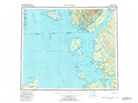
1959 Map of Prince Rupert
USGS Topo · Published 1973About this map
Dixon Entrance and the Hecate Strait dominate this mid-century maritime study of the international boundary waters between Alaska and British Columbia. The maritime economy of the late 1950s is evident in the network of coastal settlements like Prince Rupert and Port Edward, which are connected by the Canadian National Railways and a designated Ferry route. Along the Tsimpsean Peninsula, smaller outposts such as Port Simpson and Georgetown Mills sit opposite the Tongass National Forest and the Annette Island Indian Reservation. The map captures a complex shoreline of inlets and passages, including the Portland Canal and Revillagigedo Channel, where logging cabins and isolated canneries like Claxton and Arrandale once served as vital hubs for the region's salmon and timber industries.
Find a feature on this map
228 named features on this map. Tap any name to fly to it.
Don’t see what you’re looking for? This feature index may not catch every label — zoom into the map to look around manually.
Map Details
Editions of this 1959 Prince Rupert Map
5 editions found

Other maps of this area

1948 · Prince Rupert D-6
USGS Topo · 1:63,360

1948 · Dixon Entrance C-1
USGS Topo · 1:63,360

1948 · Ketchikan A-6
USGS Topo · 1:63,360

1948 · Craig A-1
USGS Topo · 1:63,360

1948 · Dixon Entrance D-1
USGS Topo · 1:63,360

1951 · Prince Rupert
USGS Topo · 1:250,000

1951 · Dixon Entrance
USGS Topo · 1:250,000

1951 · Prince Rupert D-6
USGS Topo · 1:63,360

1952 · Ketchikan
USGS Topo · 1:250,000

1955 · Ketchikan A-2
USGS Topo · 1:63,360