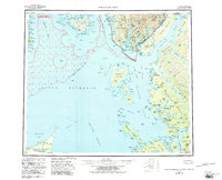
1959 Map of Prince Rupert
USGS Topo · Published 1986About this map
Prince of Wales Island and the coastal reaches of the Tsimpsean Peninsula define this international maritime landscape during the mid-20th century. The intricate shoreline is marked by the United States-Canada boundary, stretching through the Portland Canal and across Dixon Entrance. Settlement patterns reflect a deep reliance on the sea, with fishing and industrial outposts like Port Simpson, Georgetown Mills, and Claxton dotting the inlets and islands. The Canadian National Railway provides a vital link to the interior, terminating at the regional hub of Prince Rupert on Kaien Island. Much of the Alaskan territory is managed under the Tongass National Forest, including the protected reaches of the Misty Fjords National Monument Wilderness. This survey records the complex maritime geography of the Alexander Archipelago and its neighboring Canadian coast before modern development altered these remote harbors.
Find a feature on this map
86 named features on this map. Tap any name to fly to it.
Don’t see what you’re looking for? This feature index may not catch every label — zoom into the map to look around manually.
Map Details
Editions of this 1959 Prince Rupert Map
5 editions found

Other maps of this area

1948 · Prince Rupert D-6
USGS Topo · 1:63,360

1948 · Dixon Entrance C-1
USGS Topo · 1:63,360

1948 · Ketchikan A-6
USGS Topo · 1:63,360

1948 · Craig A-1
USGS Topo · 1:63,360

1948 · Dixon Entrance D-1
USGS Topo · 1:63,360

1951 · Prince Rupert
USGS Topo · 1:250,000

1951 · Dixon Entrance
USGS Topo · 1:250,000

1951 · Prince Rupert D-6
USGS Topo · 1:63,360

1952 · Ketchikan
USGS Topo · 1:250,000

1955 · Ketchikan A-2
USGS Topo · 1:63,360