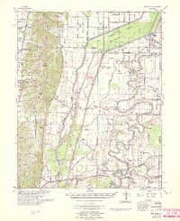
1966 Map of Princedale
USGS Topo · Published 1966About this map
The St Francis River and its complex network of floodways define the landscape of eastern Arkansas in the mid-1960s. This survey by the U. S. Army Corps of Engineers illustrates a highly engineered environment where the Donnick Floodway and numerous numbered ditches, such as Ditch No 109, drain the lowlands between the Missouri Pacific and St Louis Southwestern railroads. These transit lines supported established communities like Cherry Valley and Parkin, while also connecting smaller crossings and spurs like Colton Crossing and Smithdale Spur.
Find a feature on this map
123 named features on this map. Tap any name to fly to it.
Don’t see what you’re looking for? This feature index may not catch every label — zoom into the map to look around manually.
Map Details
Editions of this 1966 Princedale Map
This is the sole edition of this map. No revisions or reprints were ever made.
Other maps of this area

1939 · Vanndale
USGS Topo · 1:62,500

1939 · Weiner
USGS Topo · 1:62,500

1939 · Wynne
USGS Topo · 1:62,500

1939 · Edmondson
USGS Topo · 1:62,500

1940 · Deckerville
USGS Topo · 1:62,500

1940 · Princedale
USGS Topo · 1:62,500

1940 · Whitmore
USGS Topo · 1:62,500

1940 · Dee
USGS Topo · 1:62,500

1941 · Marked Tree
USGS Topo · 1:62,500

1953 · Memphis
USGS Topo · 1:250,000