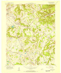
1954 Map of Princeton East
USGS Topo · Published 1955About this map
The eastern edges of Princeton and its surrounding Caldwell County farmland are defined by the heavy infrastructure of the mid-century, most notably the Illinois Central railroad lines and the Western Kentucky Agricultural Experiment Substation. The landscape transitions from the developed limits of the town toward the industrial and agricultural hubs at Cedar Bluff, where the large Cedar Bluff Quarry and Railroad Lake mark the local terrain. Small, dispersed settlements like Scottsburg and McGowan serve as nodes along the rail and road network, while the northern reaches include the protected Pennyrile Wildlife Management Area Jones-Keeney Tract.
Find a feature on this map
48 named features on this map. Tap any name to fly to it.
Don’t see what you’re looking for? This feature index may not catch every label — zoom into the map to look around manually.
Map Details
Editions of this 1954 Princeton East Map
2 editions found
Other maps of this area

1908 · Princeton
USGS Topo · 1:62,500

1909 · Dawson Springs
USGS Topo · 1:48,000

1910 · Princeton
USGS Topo · 1:62,500

1911 · Dawson Springs
USGS Topo · 1:62,500

1953 · Gracey
USGS Topo · 1:24,000

1953 · Cobb
USGS Topo · 1:24,000

1953 · Dawson Springs SW
USGS Topo · 1:24,000
1953 · Lamasco
USGS Topo · 1:24,000

1954 · Evansville
USGS Topo · 1:250,000
1954 · Princeton West
USGS Topo · 1:24,000