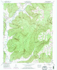
1948 Map of Princeton
USGS Topo · Published 1977About this map
The winding Paint Rock River valley serves as the primary corridor for settlement in this northeastern Alabama landscape, where the flat valley floors meet the steep rising edges of Jacobs Mountain. The village of Princeton stands at a key junction where Lick Fork meets the river, surrounded by family-named hollows and coves like Thompson Cove and Stovall Hollow. The 1948 survey reveals a community deeply rooted in its geography, with churches and burial grounds like Church Hill Cem and Prince Cem marking the points of early habitation. Higher elevations on the Cumberland Plateau remain largely forested, though natural landmarks like Indian Grave Pond and the Winding Stairs trail suggest a long history of movement through the uplands. This map documents a period before modern infrastructure bypassed these smaller rural hubs like Hollytree and Swaim.
Find a feature on this map
91 named features on this map. Tap any name to fly to it.
Don’t see what you’re looking for? This feature index may not catch every label — zoom into the map to look around manually.
Map Details
Editions of this 1948 Princeton Map
3 editions found
Other maps of this area

1888 · Scottsboro
USGS Topo · 1:125,000

1892 · Scottsboro
USGS Topo · 1:125,000

1936 · Scottsboro
USGS Topo · 1:24,000

1936 · King Cove
USGS Topo · 1:24,000

1936 · Hollytree
USGS Topo · 1:24,000

1936 · Mud Creek
USGS Topo · 1:24,000

1936 · Hytop
USGS Topo · 1:24,000

1936 · Princeton
USGS Topo · 1:24,000

1936 · Lim Rock
USGS Topo · 1:24,000
1936 · Paint Rock
USGS Topo · 1:24,000