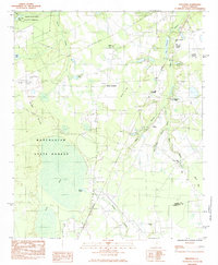
1983 Map of Privateer
USGS Topo · Published 1984About this map
Manchester State Forest dominates the western portion of this landscape, where the sandy terrain of the Sand Hills meets an expansive swamp network. The map reveals a rural South Carolina environment defined by specialized land use, including an Air to Ground Artillary Range and an Observation Tower situated within the timbered tracts. At Harvins Crossroads and the settlement of Privateer, local life is anchored by several country churches, such as Beulah Ch and Legare Ch.
Find a feature on this map
36 named features on this map. Tap any name to fly to it.
Don’t see what you’re looking for? This feature index may not catch every label — zoom into the map to look around manually.
Map Details
Editions of this 1983 Privateer Map
2 editions found
Other maps of this area

1943 · Eastover
USGS Topo · 1:62,500

1946 · Elloree
USGS Topo · 1:62,500

1946 · Sumter
USGS Topo · 1:62,500

1953 · Poinsett State Park
USGS Topo · 1:24,000

1953 · Wedgefield
USGS Topo · 1:24,000

1954 · Augusta
USGS Topo · 1:250,000

1957 · Sumter East
USGS Topo · 1:24,000

1957 · Sumter West
USGS Topo · 1:24,000

1957 · Sumter
USGS Topo · 1:62,500

1957 · Augusta
USGS Topo · 1:250,000