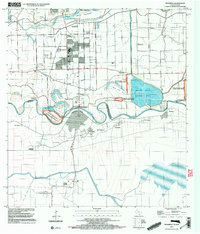
2002 Map of Progreso
USGS Topo · Published 2003About this map
Rio Grande Rio Bravo winds through a complex landscape of international commerce and conservation at the southern edge of Texas. This 2002 update, based on earlier surveys, captures the critical infrastructure of the border, including the Progreso Toll Bridge and US Customs Immigration facilities connecting Progreso with Nuevo Progreso. The map illustrates a highly managed hydrological environment, where the Llano Grande North Floodway and Main Floodway intersect with extensive irrigation systems like the Main Supply Canal.
Find a feature on this map
46 named features on this map. Tap any name to fly to it.
Don’t see what you’re looking for? This feature index may not catch every label — zoom into the map to look around manually.
Map Details
Editions of this 2002 Progreso Map
This is the sole edition of this map. No revisions or reprints were ever made.
Other maps of this area

1914 · San Juan
USGS Topo · 1:48,000

1916 · San Juan
USGS Topo · 1:62,500

1929 · Santa Maria
USGS Topo · 1:24,000

1929 · La Feria
USGS Topo · 1:24,000

1936 · La Feria
USGS Topo · 1:31,680

1936 · Santa Maria
USGS Topo · 1:31,680

1949 · Mc Allen
USGS Topo · 1:250,000

1953 · Brownsville
USGS Topo · 1:250,000

1954 · McAllen
USGS Topo · 1:250,000
1956 · La Feria
USGS Topo · 1:24,000