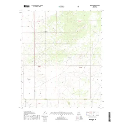
2020 Map of Progresso SW
USGS Topo · Published 2020About this map
The high plateau of the Mesa de los Jumanos dominates this landscape along the border of Socorro, Torrance, and Lincoln counties. This 2020 survey illustrates a sparsely populated region of central New Mexico, where the terrain transitions into the expanse of Atkinson Flats. The land is largely defined by the boundaries of the Cibola National Forest, showing a network of rural routes such as Forest 458 Rd and Lindsey Rd that connect isolated stock tanks and ranching tracts.
Find a feature on this map
17 named features on this map. Tap any name to fly to it.
Don’t see what you’re looking for? This feature index may not catch every label — zoom into the map to look around manually.
Map Details
Editions of this 2020 Progresso SW Map
This is the sole edition of this map. No revisions or reprints were ever made.
Other maps of this area

1954 · Fort Sumner
USGS Topo · 1:250,000

1954 · Socorro
USGS Topo · 1:250,000

1958 · Socorro
USGS Topo · 1:250,000

1958 · Fort Sumner
USGS Topo · 1:250,000

1962 · Socorro
USGS Topo · 1:250,000

1972 · Gran Quivira
USGS Topo · 1:24,000
1972 · Turkey Ridge NE
USGS Topo · 1:24,000
1972 · Round Top
USGS Topo · 1:24,000
1979 · Socorro
USGS Topo · 1:100,000

1980 · Corona
USGS Topo · 1:100,000