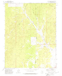
1972 Map of Prohibition Flat
USGS Topo · Published 1974About this map
The Nevada Utah border country is defined by high-elevation drainage systems and scattered water sources in this 1970s survey. The landscape transitions from the southern reaches of the Paradise Mts into the alluvial basin of Prohibition Flat. This arid region relies heavily on isolated water points such as Prohibition Spring, Newels Spring, and Mud Spring to support livestock or transit through the high desert.
Find a feature on this map
14 named features on this map. Tap any name to fly to it.
Don’t see what you’re looking for? This feature index may not catch every label — zoom into the map to look around manually.
Map Details
Editions of this 1972 Prohibition Flat Map
2 editions found
Other maps of this area

1885 · St. George
USGS Topo · 1:250,000

1885 · Pioche
USGS Topo · 1:250,000

1886 · Pioche
USGS Topo · 1:250,000

1891 · St. George
USGS Topo · 1:250,000

1953 · Cedar City
USGS Topo · 1:250,000

1954 · Caliente
USGS Topo · 1:250,000

1958 · Cedar City
USGS Topo · 1:250,000

1959 · Caliente
USGS Topo · 1:250,000

1962 · Cedar City
USGS Topo · 1:250,000
1972 · Panaca Summit
USGS Topo · 1:24,000