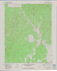
1972 Map of Prohibition Flat
USGS Topo · Published 1990About this map
Prohibition Flat serves as the focal point of this 1970s landscape, positioned along the border between Nevada and Utah. This arid, high-desert terrain is defined by its water sources and drainage patterns, including the prominent Rose Valley Reservoir and numerous ephemeral channels such as Midnight Wash and Gold Springs Wash. The eastern portion of the sheet is dominated by the Paradise Mts, where seasonal springs like Mud Spring and Trough Spring provided critical resources for early activity in the region. Evidence of historical exploration and small-scale resource extraction is visible through several marked Prospect sites. The map clearly delineates the Nevada-Utah state line and the junction of Lincoln and Iron counties, illustrating how these political boundaries intersect with the natural geography of the Great Basin.
Find a feature on this map
13 named features on this map. Tap any name to fly to it.
Don’t see what you’re looking for? This feature index may not catch every label — zoom into the map to look around manually.
Map Details
Editions of this 1972 Prohibition Flat Map
2 editions found
Other maps of this area

1885 · St. George
USGS Topo · 1:250,000

1885 · Pioche
USGS Topo · 1:250,000

1886 · Pioche
USGS Topo · 1:250,000

1891 · St. George
USGS Topo · 1:250,000

1953 · Cedar City
USGS Topo · 1:250,000

1954 · Caliente
USGS Topo · 1:250,000

1958 · Cedar City
USGS Topo · 1:250,000

1959 · Caliente
USGS Topo · 1:250,000

1962 · Cedar City
USGS Topo · 1:250,000
1972 · Panaca Summit
USGS Topo · 1:24,000