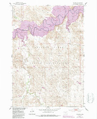
1951 Map of Promise
USGS Topo · Published 1987About this map
The settlement of Promise and the surrounding landscape of the Cheyenne River Indian Reservation are documented here during a period of significant hydrological change. The wide, meandering course of the Moreau River dominates the northern terrain, where it meets the rising waters of Lake Oahe. This 1950s survey, with later photorevisions, captures the intersection of traditional river geography and the massive Missouri River Basin development projects that altered the South Dakota landscape. Tributaries such as Laundreaux Creek, Tom Hill Creek, and Ducharme Creek drain the dissected uplands into the river valley. The map also traces a dismantled rail line that once served the community of Promise, offering a look at the region's evolving transportation infrastructure and the impact of the reservoir on local settlements.
Find a feature on this map
13 named features on this map. Tap any name to fly to it.
Don’t see what you’re looking for? This feature index may not catch every label — zoom into the map to look around manually.
Map Details
Editions of this 1951 Promise Map
2 editions found
Other maps of this area

1951 · Virginia
USGS Topo · 1:24,000

1951 · La Plant
USGS Topo · 1:24,000

1951 · Promise
USGS Topo · 1:24,000

1952 · Trail City SW
USGS Topo · 1:24,000

1953 · McIntosh
USGS Topo · 1:250,000

1958 · McIntosh
USGS Topo · 1:250,000

1968 · Moreau NW
USGS Topo · 1:24,000

1968 · Moreau
USGS Topo · 1:24,000

1970 · Patch Skin Buttes
USGS Topo · 1:24,000

1975 · Laundreaux Butte
USGS Topo · 1:24,000