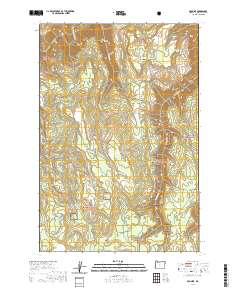
2020 Map of Promise
USGS Topo · Published 2020About this map
The settlement of Promise anchors this remote section of northeast Oregon, situated atop the plateaus that separate deep canyon drainages. To the north, the Grande Ronde Wild and Scenic River carves a dramatic loop through the terrain, its banks marking the boundary between vast sections of the Wallowa National Forest. The map illustrates a landscape defined by sharp transitions from open grassy areas like Ray Flat and McNutt Flat to the steep, timbered descents of Ward Canyon. A network of unpaved arteries, including Promise Rd and Sickfoot Rd, connects the scattered high-ground features. Water is channeled through numerous seasonal and perennial flows such as Sickfoot Cr and Wallupa Cr, which feed into the larger river system, while local landmarks like Hendersons Pond and Mid Point serve as essential reference points in this high-elevation wilderness.
Find a feature on this map
25 named features on this map. Tap any name to fly to it.
Don’t see what you’re looking for? This feature index may not catch every label — zoom into the map to look around manually.
Map Details
Editions of this 2020 Promise Map
This is the sole edition of this map. No revisions or reprints were ever made.
Other maps of this area

1955 · Grangeville
USGS Topo · 1:250,000

1957 · Sled Springs
USGS Topo · 1:62,500

1959 · Grangeville
USGS Topo · 1:250,000

1964 · Howard Butte
USGS Topo · 1:24,000

1964 · Akers Butte
USGS Topo · 1:24,000

1967 · Wood Butte
USGS Topo · 1:24,000

1967 · Troy
USGS Topo · 1:24,000

1967 · Eden
USGS Topo · 1:24,000

1967 · Elbow Creek
USGS Topo · 1:24,000

1967 · Promise
USGS Topo · 1:24,000