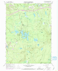
1966 Map of Promised Land
USGS Topo · Published 1988About this map
Promised Land State Park serves as the central anchor of this Pike County landscape, a dense network of glacial lakes, swamps, and ridges. The 1960s terrain shows a transition from the preserved wilderness of the park and surrounding State Forest to the small rural clusters at Blooming Grove and Roemersville. Local institutional history is concentrated in the northeast at the Blooming Grove Cem, Blooming Grove Sch, and Good Shepherd Ch. The map illustrates a landscape defined by water and high ground, from the heights of High Knob and its Lookout Tower to the expansive wetlands of Panther Swamp and Balsam Swamp. Recreational development is evident in the Campgrounds near Conservation Island and a Golf Course tucked between the ridges near Bear Trap Mountain.
Find a feature on this map
78 named features on this map. Tap any name to fly to it.
Don’t see what you’re looking for? This feature index may not catch every label — zoom into the map to look around manually.
Map Details
Editions of this 1966 Promised Land Map
3 editions found
Other maps of this area

1919 · Pocono
USGS Topo · 1:62,500

1921 · Pocono
USGS Topo · 1:62,500

1923 · Pocono
USGS Topo · 1:62,500

1924 · Bushkill
USGS Topo · 1:48,000

1928 · Ariel
USGS Topo · 1:62,500

1932 · Ariel
USGS Topo · 1:62,500

1935 · Hawley
USGS Topo · 1:62,500

1938 · Hawley
USGS Topo · 1:62,500

1943 · Bushkill
USGS Topo · 1:62,500

1943 · Pocono
USGS Topo · 1:62,500
Featured Places
- Blooming Grove Township, PA
- Greene Township, PA
- Porter Township, PA
- Tanglewood Estate, Palmyra Township
- Roemersville, Greene Township