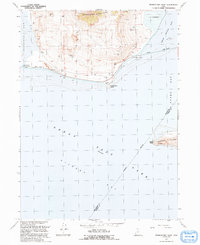
1991 Map of Promontory Point
USGS Topo · Published 1991About this map
The Promontory Mountains terminate at the northern shores of the Great Salt Lake in this 1991 survey. This unique geography is dominated by the Lucin Cutoff, a railroad and roadway achievement that traverses the waters of Gunnison Bay and Bear River Bay via a massive causeway. At the southern tip of the peninsula, the small settlement of Saline and the geographic Promontory Point stand near industrial infrastructure including a pumping station and elevated aqueduct. The map captures the high-water and low-water realities of the lake, noting an indefinite boundary between Box Elder and Weber counties. On the eastern edge, the topography of Fremont Island rises from Ogden Bay, featuring Miller Point and a small prospect. Numerous gravel pits and quarries dot the southern slopes of the mountains, suggesting a landscape shaped by both natural forces and heavy extraction.
Find a feature on this map
26 named features on this map. Tap any name to fly to it.
Don’t see what you’re looking for? This feature index may not catch every label — zoom into the map to look around manually.
Map Details
Editions of this 1991 Promontory Point Map
This is the sole edition of this map. No revisions or reprints were ever made.
Other maps of this area

1954 · Brigham City
USGS Topo · 1:250,000

1955 · Willard Spur
USGS Topo · 1:24,000

1955 · Fremont Island
USGS Topo · 1:24,000

1958 · Brigham City
USGS Topo · 1:250,000

1962 · Brigham City
USGS Topo · 1:250,000

1968 · Indian Cove
USGS Topo · 1:24,000

1968 · Pokes Point
USGS Topo · 1:24,000

1968 · Promontory Point
USGS Topo · 1:24,000

1968 · Fremont Island SW
USGS Topo · 1:24,000

1968 · Carrington Island
USGS Topo · 1:24,000