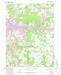
1961 Map of Prospect
USGS Topo · Published 1981About this map
Lake Arthur dominates the central landscape of this Butler County region, its winding shoreline and numerous inlets such as Nealeys Creek and Big Run defining the topography. This 1961 survey, updated with 1970 revisions, illustrates a rural Pennsylvania landscape transitioning between traditional agriculture and industrial activity. Evidence of the local extraction economy is visible through numerous Oil Wells and Strip Mines scattered across the townships of Worth, Brady, and Franklin.
Find a feature on this map
53 named features on this map. Tap any name to fly to it.
Don’t see what you’re looking for? This feature index may not catch every label — zoom into the map to look around manually.
Map Details
Editions of this 1961 Prospect Map
Other maps of this area

1908 · Zelienople
USGS Topo · 1:62,500

1909 · Butler
USGS Topo · 1:62,500

1910 · Zelienople
USGS Topo · 1:62,500

1910 · Hilliards
USGS Topo · 1:62,500

1911 · Butler
USGS Topo · 1:62,500

1912 · Hilliards
USGS Topo · 1:62,500

1913 · Mercer
USGS Topo · 1:62,500

1939 · Mercer
USGS Topo · 1:62,500

1943 · Mercer
USGS Topo · 1:62,500

1944 · Hilliards
USGS Topo · 1:62,500