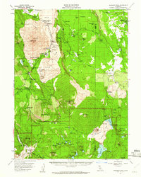
1957 Map of Prospect Peak
USGS Topo · Published 1961About this map
Lava flows and volcanic topography dominate this portion of the Shasta and Lassen County border, where the high-altitude landscape of Lassen Volcanic National Park meets the Lassen National Forest. The map documents a rugged volcanic wilderness characterized by the Fantastic Lava Beds, the Painted Dunes, and distinctive peaks like Prospect Peak and Cinder Cone. Settlement is sparse, focused around the Old Station (PO) and various campgrounds such as Bridge Campground and Cave Campground along Hat Creek.
Find a feature on this map
97 named features on this map. Tap any name to fly to it.
Don’t see what you’re looking for? This feature index may not catch every label — zoom into the map to look around manually.
Map Details
Editions of this 1957 Prospect Peak Map
3 editions found

Other maps of this area

1886 · Lassen Peak
USGS Topo · 1:250,000

1892 · Lassen Peak
USGS Topo · 1:250,000

1894 · Lassen Peak
USGS Topo · 1:250,000

1935 · Burney
USGS Topo · 1:96,000

1935 · Paynes Creek
USGS Topo · 1:96,000

1939 · Burney
USGS Topo · 1:125,000

1939 · Halls Flat
USGS Topo · 1:125,000

1941 · Mineral
USGS Topo · 1:125,000

1955 · Westwood
USGS Topo · 1:250,000

1956 · Lassen Peak
USGS Topo · 1:62,500