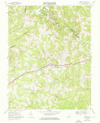
1967 Map of Prospect
USGS Topo · Published 1975About this map
The Norfolk And Western railroad corridor serves as the primary east-west artery through this portion of Prince Edward County, anchoring the community of Prospect. This mid-century landscape is defined by the winding course of the Appomattox River, which forms the northern boundary where historical crossing points like Beazley Ford and Venables Bridge connect the hills of Buckingham and Prince Edward. The terrain is deeply dissected by numerous watercourses, including Vaughans Creek and Harris Creek, creating a rural pattern of ridge-top settlements and creek-bottom agriculture.
Find a feature on this map
34 named features on this map. Tap any name to fly to it.
Don’t see what you’re looking for? This feature index may not catch every label — zoom into the map to look around manually.
Map Details
Editions of this 1967 Prospect Map
3 editions found
Other maps of this area

1891 · Farmville
USGS Topo · 1:125,000

1892 · Appomattox
USGS Topo · 1:125,000

1893 · Farmville
USGS Topo · 1:125,000

1947 · Roanoke
USGS Topo · 1:250,000

1956 · Charlotte Court House
USGS Topo · 1:62,500

1958 · Farmville
USGS Topo · 1:62,500

1958 · Keysville
USGS Topo · 1:62,500

1958 · Pamplin City
USGS Topo · 1:62,500

1959 · Roanoke
USGS Topo · 1:250,000

1963 · Roanoke
USGS Topo · 1:250,000