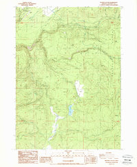
1988 Map of Prospect South
USGS Topo · Published 1988About this map
The Rogue River and its various tributaries define this section of the Rogue River National Forest during the late 1980s. Water management and resource extraction are central to the landscape, evidenced by an Elevated Aqueduct and Aqueduct system near the Substation and Powerhouse, alongside numerous Borrow Pits and Quarry sites. The settlement of Prospect sits at the northwestern edge, supported by the Prospect Airport and the nearby Prospect State Wayside, which overlooks the dramatic Mill Cr Falls.
Find a feature on this map
46 named features on this map. Tap any name to fly to it.
Don’t see what you’re looking for? This feature index may not catch every label — zoom into the map to look around manually.
Map Details
Editions of this 1988 Prospect South Map
This is the sole edition of this map. No revisions or reprints were ever made.
Other maps of this area

1891 · Ashland
USGS Topo · 1:250,000

1893 · Ashland
USGS Topo · 1:250,000

1897 · Ashland
USGS Topo · 1:250,000

1944 · Abbott Butte
USGS Topo · 1:62,500

1947 · Abbott Butte
USGS Topo · 1:62,500

1954 · Butte Falls
USGS Topo · 1:62,500

1955 · Rustler Peak
USGS Topo · 1:62,500

1955 · Medford
USGS Topo · 1:250,000

1956 · Prospect
USGS Topo · 1:62,500

1957 · Medford
USGS Topo · 1:250,000