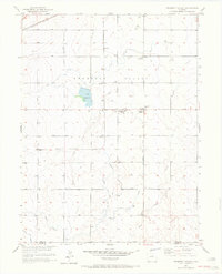
1950 Map of Prospect Valley
USGS Topo · Published 1972About this map
Prospect Valley serves as a central point in this mid-century agricultural landscape, defined by an intricate network of irrigation systems and small rural clusters. The map details the vital water management infrastructure of the era, including the Low Line Canal, Henrylyn Canal, and several laterals that supported the region's farms. Scattered across the plains are local family-named landmarks and small settlements like Krauss, Johnson, and Sheehan, reflecting a period of localized rural activity before major demographic shifts.
Find a feature on this map
19 named features on this map. Tap any name to fly to it.
Don’t see what you’re looking for? This feature index may not catch every label — zoom into the map to look around manually.
Map Details
Editions of this 1950 Prospect Valley Map
4 editions found
Other maps of this area

1890 · East Denver
USGS Topo · 1:125,000

1902 · Greeley
USGS Topo · 1:125,000

1949 · Sunnydale
USGS Topo · 1:24,000

1950 · South Roggen
USGS Topo · 1:24,000

1950 · Tampa
USGS Topo · 1:24,000

1950 · Keenesburg
USGS Topo · 1:24,000

1950 · Prospect Valley
USGS Topo · 1:24,000

1950 · Klug Ranch
USGS Topo · 1:24,000

1951 · Keenesburg
USGS Topo · 1:24,000

1951 · Prospect Valley
USGS Topo · 1:24,000