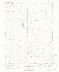
1950 Map of Prospect Valley
USGS Topo · Published 1972About this map
Prospect Valley is revealed here as an intricate agricultural corridor defined by the management of water across the High Plains. The landscape is dominated by a systematic network of irrigation infrastructure, including the Low Line Canal, the Prospect Lateral Ditch, and the Henrylyn Canal (Abandoned). These man-made waterways contrast with the natural courses of Lost Creek and Sand Creek, highlighting the transition from dry range to productive farmland. Small community clusters such as Krauss, Johnson, and Sheehan are interspersed with specialized landmarks like the USBR Prospect Valley Sub Station and the Prospect Valley School. The northern edge of the valley is traced by the Burlington Northern railroad, which historically served as the lifeline for these rural settlements. This survey provides a precise record of the family-named landmarks and water rights that shaped the local economy in the mid-20th century.
Find a feature on this map
18 named features on this map. Tap any name to fly to it.
Don’t see what you’re looking for? This feature index may not catch every label — zoom into the map to look around manually.
Map Details
Editions of this 1950 Prospect Valley Map
4 editions found
Other maps of this area

1890 · East Denver
USGS Topo · 1:125,000

1902 · Greeley
USGS Topo · 1:125,000

1949 · Sunnydale
USGS Topo · 1:24,000

1950 · South Roggen
USGS Topo · 1:24,000

1950 · Tampa
USGS Topo · 1:24,000

1950 · Keenesburg
USGS Topo · 1:24,000

1950 · Prospect Valley
USGS Topo · 1:24,000

1950 · Klug Ranch
USGS Topo · 1:24,000

1951 · Keenesburg
USGS Topo · 1:24,000

1951 · Prospect Valley
USGS Topo · 1:24,000