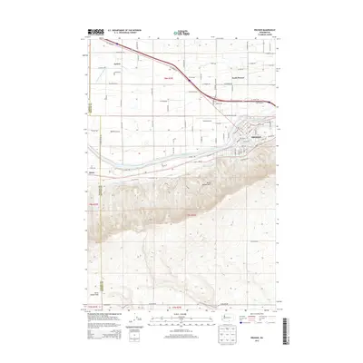
2013 Map of Prosser
USGS Topo · Published 2013About this map
The Yakima River flows through the heart of this landscape, serving as the historical and geographic anchor for the city of Prosser. This 2013 survey illustrates the complex irrigation network vital to the region's agriculture, featuring the Mabton Feeder Lateral, Prosser W Lateral, and Mabton E Lateral. The topography is dominated by the rising slopes of the Horse Heaven Hills to the south, which overlook the river valley and the developed areas of North Prosser. Transportation history is evident in the alignment of the Old Inland Empire Hwy and the presence of the Prosser Airport. Smaller settlements and localities like Apricot and Byron are situated along the valley floor, connected by a grid of rural roads including W Co Road 12 and W Sellars Rd.
Find a feature on this map
49 named features on this map. Tap any name to fly to it.
Don’t see what you’re looking for? This feature index may not catch every label — zoom into the map to look around manually.
Map Details
Editions of this 2013 Prosser Map
This is the sole edition of this map. No revisions or reprints were ever made.
Other maps of this area

1915 · Prosser
USGS Topo · 1:125,000

1917 · Prosser
USGS Topo · 1:125,000

1950 · Grandview
USGS Topo · 1:62,500

1951 · Grandview
USGS Topo · 1:62,500

1951 · Corral Canyon
USGS Topo · 1:62,500

1953 · Walla Walla
USGS Topo · 1:250,000

1955 · Prosser SW
USGS Topo · 1:24,000

1958 · Walla Walla
USGS Topo · 1:250,000

1965 · Whitstran
USGS Topo · 1:62,500
1965 · Prosser
USGS Topo · 1:62,500