
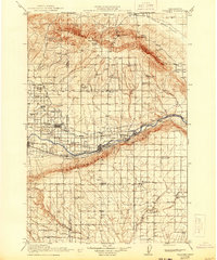
1917 Map of Prosser
USGS Topo · Published 1917About this map
The Yakima River valley serves as the central artery for this 1917 portrait of a transforming Washington landscape. The irrigation infrastructure of the Sunnyside Canal supports the growing agricultural communities of Prosser, Grandview, and Mabton. The presence of a Gas Well in the northern hills and the intersecting lines of the Northern Pacific and the Oregon Washington Railroad & Navigation Co reveal the area's early industrial and transport ambitions.
Find a feature on this map
56 named features on this map. Tap any name to fly to it.
Don’t see what you’re looking for? This feature index may not catch every label — zoom into the map to look around manually.
Map Details
Editions of this 1917 Prosser Map
2 editions found
Other maps of this area

1906 · Blalock Island
USGS Topo · 1:125,000

1908 · Blalock Island
USGS Topo · 1:125,000

1908 · Umatilla
USGS Topo · 1:125,000

1910 · Zillah
USGS Topo · 1:125,000

1915 · Prosser
USGS Topo · 1:125,000

1916 · Arlington
USGS Topo · 1:125,000

1916 · Coyote Rapids
USGS Topo · 1:62,500

1917 · Pasco
USGS Topo · 1:125,000

1917 · Priest Rapids
USGS Topo · 1:62,500

1924 · Hanford
USGS Topo · 1:62,500