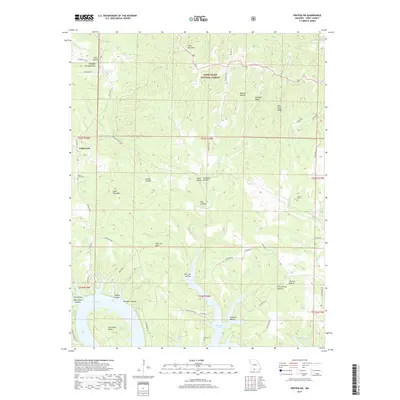
2017 Map of Protem SW
USGS Topo · Published 2017About this map
Cedarcreek sits within a complex landscape of narrow ridges and steep hollows just north of the Arkansas border in Taney County. The terrain is defined by the winding southern shoreline of Bull Shoals Lake, where the White River valley was transformed by mid-century inundation. Significant topographical features like Poor Joe Bald, Lone Tree Mtn, and Lime Kiln Mtn rise above a dense network of drainages including Yocum Cr and Elbow Cr. Much of the northern half of the sheet is managed as part of the Mark Twain National Forest. Local history is preserved through numerous family-named landmarks such as Hankins Hollow and Clemens Hollow, alongside small burial sites like Cedar Creek Cem and Ray Cem. The road network, including the suggestive Nave Ferry Rd, hints at earlier river crossings and transportation routes that predated the reservoir.
Find a feature on this map
66 named features on this map. Tap any name to fly to it.
Don’t see what you’re looking for? This feature index may not catch every label — zoom into the map to look around manually.
Map Details
Editions of this 2017 Protem SW Map
This is the sole edition of this map. No revisions or reprints were ever made.
Other maps of this area

1893 · Yellville
USGS Topo · 1:125,000

1903 · Yellville
USGS Topo · 1:125,000

1904 · Harrison
USGS Topo · 1:125,000

1905 · Harrison
USGS Topo · 1:125,000

1905 · Yellville
USGS Topo · 1:125,000

1907 · Forsyth
USGS Topo · 1:125,000

1929 · Yellville
USGS Topo · 1:125,000

1943 · Protem
USGS Topo · 1:62,500

1945 · Harrison
USGS Topo · 1:250,000

1949 · Harrison
USGS Topo · 1:250,000