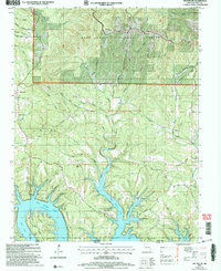
2004 Map of Protem SW
USGS Topo · Published 2006About this map
The Ozark plateau along the Missouri-Arkansas border is defined here by the jagged, flooded fingers of Bull Shoals Lake and the dense timber of the Mark Twain National Forest. The map documents a landscape where steep ridges like Hankins Ridge and Mill Ridge overlook the winding White River valley. While much of the land remains wooded, the small settlement of Cedarcreek serves as a local hub near the Cedar Creek Cem. Local history is preserved in the names of family landmarks and hollows, such as Cardwell Hollow and Poor Joe Bald. Transport across this difficult terrain is marked by older routes like Ferry Road and the specialized Bright Elbow Ranch Landing Field, illustrating how residents adapted to the deep valleys and rising waters of the mid-twentieth century.
Find a feature on this map
45 named features on this map. Tap any name to fly to it.
Don’t see what you’re looking for? This feature index may not catch every label — zoom into the map to look around manually.
Map Details
Editions of this 2004 Protem SW Map
This is the sole edition of this map. No revisions or reprints were ever made.
Other maps of this area

1893 · Yellville
USGS Topo · 1:125,000

1903 · Yellville
USGS Topo · 1:125,000

1904 · Harrison
USGS Topo · 1:125,000

1905 · Harrison
USGS Topo · 1:125,000

1905 · Yellville
USGS Topo · 1:125,000

1907 · Forsyth
USGS Topo · 1:125,000

1929 · Yellville
USGS Topo · 1:125,000

1943 · Protem
USGS Topo · 1:62,500

1945 · Harrison
USGS Topo · 1:250,000

1949 · Harrison
USGS Topo · 1:250,000