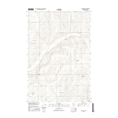
2017 Map of Providence
USGS Topo · Published 2017About this map
Providence stands as a focal point in this portion of Adams County, where the dry landscape is defined by the significant geographic depressions of Providence Coulee and Cunningham Coulee. The 2017 survey reveals a strictly organized rural grid system, with the settlement of Lind positioned in the northeast and Servia to the west. This agricultural region is laced with a network of long-distance connector roads, including Lind-Hatton Rd and Lind-Warden Rd, which follow the natural contours of the coulees and the township boundaries. The map provides a clear view of the Public Land Survey System (PLSS) divisions, such as t17n r33e and t16n r33e, which underpin the property lines and farm layouts of this Eastern Washington wheat-growing territory. Researchers can trace local transit routes like Providence Rd and Hoffman Rd across the undulating terrain between these sparse rail-aligned communities.
Find a feature on this map
27 named features on this map. Tap any name to fly to it.
Don’t see what you’re looking for? This feature index may not catch every label — zoom into the map to look around manually.
Map Details
Editions of this 2017 Providence Map
This is the sole edition of this map. No revisions or reprints were ever made.
Other maps of this area

1916 · Connell
USGS Topo · 1:125,000

1918 · Connell
USGS Topo · 1:125,000

1925 · Schrag
USGS Topo · 1:62,500

1953 · Walla Walla
USGS Topo · 1:250,000

1953 · Ritzville
USGS Topo · 1:250,000

1958 · Walla Walla
USGS Topo · 1:250,000

1959 · Ritzville
USGS Topo · 1:250,000

1965 · Ritzville
USGS Topo · 1:250,000

1967 · Reiman SW
USGS Topo · 1:24,000
1967 · Schrag
USGS Topo · 1:24,000