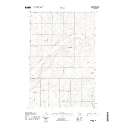
2020 Map of Providence
USGS Topo · Published 2020About this map
Lind serves as the northern anchor for this Adams County landscape, where the high desert terrain is carved by significant geological depressions. The Palouse To Cascades State Park Trail cuts a diagonal path across the territory, following a historic rail corridor that once connected the coast to the interior. This transportation legacy is echoed by a grid of rural roads named for local families, including Hoffman Rd, Lauer Rd, and Wahl Rd, which weave between the dry land farming parcels.
Find a feature on this map
28 named features on this map. Tap any name to fly to it.
Don’t see what you’re looking for? This feature index may not catch every label — zoom into the map to look around manually.
Map Details
Editions of this 2020 Providence Map
This is the sole edition of this map. No revisions or reprints were ever made.
Other maps of this area

1916 · Connell
USGS Topo · 1:125,000

1918 · Connell
USGS Topo · 1:125,000

1925 · Schrag
USGS Topo · 1:62,500

1953 · Walla Walla
USGS Topo · 1:250,000

1953 · Ritzville
USGS Topo · 1:250,000

1958 · Walla Walla
USGS Topo · 1:250,000

1959 · Ritzville
USGS Topo · 1:250,000

1965 · Ritzville
USGS Topo · 1:250,000

1967 · Reiman SW
USGS Topo · 1:24,000
1967 · Schrag
USGS Topo · 1:24,000