
1944 Map of Providence
USGS Topo · Published 1944About this map
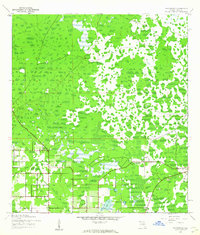
Providence and the surrounding wetlands of Polk County are captured here at the height of World War II, showing a landscape defined by citrus groves and early aviation infrastructure. The Corps of Engineers document an Auxiliary Landing Field in the southwest, while much of the central and northern terrain consists of dense woodland, scattered brush, and marshy lowlands near Sick Lake.
Find a feature on this map
11 named features on this map. Tap any name to fly to it.
Don’t see what you’re looking for? This feature index may not catch every label — zoom into the map to look around manually.
Map Details
Editions of this 1944 Providence Map
2 editions found
Other maps of this area

1944 · Plant City
USGS Topo · 1:31,680

1944 · Polk City
USGS Topo · 1:31,680

1944 · Lakeland
USGS Topo · 1:31,680

1944 · Auburndale
USGS Topo · 1:31,680

1944 · Socrum
USGS Topo · 1:31,680

1955 · Plant City
USGS Topo · 1:250,000

1955 · Orlando
USGS Topo · 1:250,000

1957 · Orlando
USGS Topo · 1:250,000

1958 · Orlando
USGS Topo · 1:250,000

1958 · Plant City
USGS Topo · 1:250,000