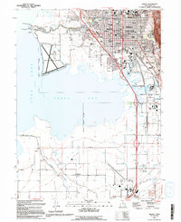
1993 Map of Provo
USGS Topo · Published 1994About this map
The eastern shores of Utah Lake reveal a complex interface of urban development and hydraulic engineering, centered on the city of Provo. This 1993 edition, based on earlier surveys and field-checked in 1990, depicts a landscape defined by its proximity to the water, where the Provo River meets the lake at Utah Lake State Park. A extensive system of levees and the Road on Levee protect the low-lying shoreline and the Provo Municipal Airport. Cultural and institutional infrastructure is dense throughout the city, featuring Brigham Young University, the Utah State Hospital, and the Provo City Cem. To the south, the map follows the Union Pacific and Denver and Rio Grande Western railroads as they traverse toward Springville, passing the Suntana Raceway and the rural settlement of Palmyra.
Find a feature on this map
63 named features on this map. Tap any name to fly to it.
Don’t see what you’re looking for? This feature index may not catch every label — zoom into the map to look around manually.
Map Details
Editions of this 1993 Provo Map
2 editions found
Other maps of this area

1885 · Salt Lake
USGS Topo · 1:250,000

1948 · Spanish Fork
USGS Topo · 1:24,000

1948 · Orem
USGS Topo · 1:24,000

1948 · Orem
USGS Topo · 1:62,500

1948 · Springville
USGS Topo · 1:24,000

1948 · Provo
USGS Topo · 1:24,000

1948 · Bridal Veil Falls
USGS Topo · 1:24,000

1949 · Provo
USGS Topo · 1:62,500

1949 · Spanish Fork Peak
USGS Topo · 1:24,000

1950 · Orem
USGS Topo · 1:24,000