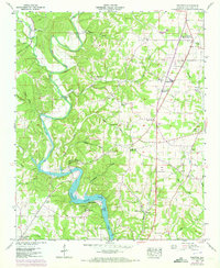
1952 Map of Pruitton
USGS Topo · Published 1973About this map
Shoal Creek meanders south toward the impounded waters of Wilson Lake in this mid-century portrait of Lauderdale County. The landscape is defined by the convergence of agricultural plateaus and deeply cut drainage branches like Cowpen Creek and Keithly Branch. The cultural imprint of the era is visible in the scattered rural community hubs of Pruitton, Green Hill, and St Florian, alongside numerous country churches such as Grays Chapel and Lone Cedar Ch.
Find a feature on this map
55 named features on this map. Tap any name to fly to it.
Don’t see what you’re looking for? This feature index may not catch every label — zoom into the map to look around manually.
Map Details
Editions of this 1952 Pruitton Map
3 editions found
Other maps of this area

1905 · Waynesboro
USGS Topo · 1:125,000

1914 · Rogersville
USGS Topo · 1:48,000

1914 · Muscle Shoals
USGS Topo · 1:48,000

1916 · Muscle Shoals
USGS Topo · 1:62,500

1916 · Rogersville
USGS Topo · 1:62,500

1936 · Light
USGS Topo · 1:24,000

1936 · Loretto
USGS Topo · 1:24,000

1936 · Pruitton
USGS Topo · 1:24,000

1936 · Wheeler Dam
USGS Topo · 1:24,000

1936 · Florence
USGS Topo · 1:24,000