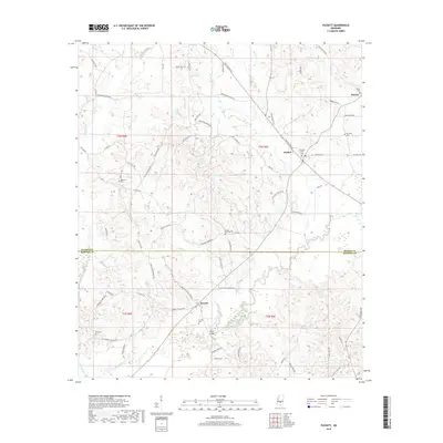
2018 Map of Puckett
USGS Topo · Published 2018About this map
The Strong River winds through the central and southern reaches of this landscape, marking the transition across the Rankin and Simpson County line. The settlement of Puckett serves as a local hub near the intersection of several rural routes, while smaller locales like Everett and Mayton anchor the surrounding agricultural and timber lands. This territory is characterized by numerous small family and community burial grounds, such as Puckett Cem and Rosehill Cem, which provide essential points of reference for genealogical research. A notable historical feature is the Old Railroad Grade running northwest of Puckett, a physical remnant of earlier industrial transportation through the piney woods. Tributaries like Wildcat Creek and Clear Creek feed into the river system, defining the drainage patterns that shaped the placement of early homesteads and crossings like Floyd Bridge.
Find a feature on this map
68 named features on this map. Tap any name to fly to it.
Don’t see what you’re looking for? This feature index may not catch every label — zoom into the map to look around manually.
Map Details
Editions of this 2018 Puckett Map
This is the sole edition of this map. No revisions or reprints were ever made.
Other maps of this area

1935 · White Oak
USGS Topo · 1:24,000

1953 · Hattiesburg
USGS Topo · 1:250,000

1953 · Meridian
USGS Topo · 1:250,000

1957 · Meridian
USGS Topo · 1:250,000

1958 · Hattiesburg
USGS Topo · 1:250,000

1965 · Meridian
USGS Topo · 1:250,000
1968 · Puckett NW
USGS Topo · 1:24,000

1968 · White Oak
USGS Topo · 1:24,000
1968 · Puckett
USGS Topo · 1:24,000
1968 · Polkville
USGS Topo · 1:24,000