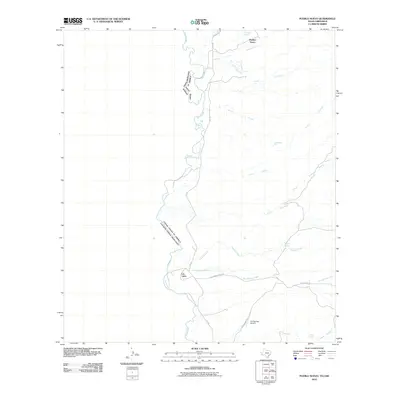
2010 Map of Pueblo Nuevo
USGS Topo · Published 2010About this map
Pueblo Nuevo and the small settlement of Las Lulas overlook the Rio Grande in this borderland survey along the Texas-Chihuahua divide. The landscape is defined by an intricate network of drainage systems, with numerous seasonal watercourses including Arroyo El Muerto, Arroyo Santana, and Arroyo Sanguijuela carving through the terrain toward the river. Vital water sources are scattered throughout this arid region, marked by sites such as Ranchita Spring, Naegele Springs, and Tijeras Spring. Transportation is limited to the corridor of FM 170 and Hot Springs Rd, which connects remote ranching areas to the Hot Springs Airport. The map documents a sparsely populated but geographically complex environment where international boundaries follow the shifting path of the river, and traditional land use is reflected in features like the Chupadera Pila and various tinajas.
Find a feature on this map
23 named features on this map. Tap any name to fly to it.
Don’t see what you’re looking for? This feature index may not catch every label — zoom into the map to look around manually.
Map Details
Editions of this 2010 Pueblo Nuevo Map
This is the sole edition of this map. No revisions or reprints were ever made.
Other maps of this area

1896 · Ruidosa
USGS Topo · 1:125,000

1896 · San Carlos
USGS Topo · 1:125,000

1959 · Presidio
USGS Topo · 1:250,000

1959 · Marfa
USGS Topo · 1:250,000

1965 · Presidio
USGS Topo · 1:250,000

1965 · Marfa
USGS Topo · 1:250,000

1978 · Sierra Parda
USGS Topo · 1:24,000

1979 · Ruidosa Hot Springs
USGS Topo · 1:24,000

1979 · Capote Falls
USGS Topo · 1:24,000
1979 · Candelaria
USGS Topo · 1:24,000