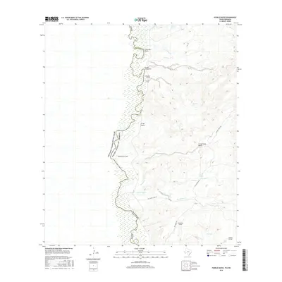
2016 Map of Pueblo Nuevo
USGS Topo · Published 2016About this map
The Rio Grande serves as the prominent western boundary in this remote corner of Presidio County, where the international border with Mexico follows the river's winding course. This high-desert landscape is defined by its drainage systems and critical water sources, including Naegele Springs, Ranchita Spring, and the wetland area of La Cienega. The transport network is sparse, centered on FM 170 and rugged routes like Hot Springs Creek Rd, which provide access to isolated landmarks such as Hot Springs Airport. Numerous ephemeral waterways, such as Sanguijuela Arroyo, Arroyo Chupaderos, and Tijeras Arroyo, carve through the terrain, illustrating the dramatic hydrology of the Trans-Pecos. The placement of Chupadera Pila and various spring sites highlights the historical importance of reliable water for ranching and survival in this arid borderland environment.
Find a feature on this map
24 named features on this map. Tap any name to fly to it.
Don’t see what you’re looking for? This feature index may not catch every label — zoom into the map to look around manually.
Map Details
Editions of this 2016 Pueblo Nuevo Map
This is the sole edition of this map. No revisions or reprints were ever made.
Other maps of this area

1896 · Ruidosa
USGS Topo · 1:125,000

1896 · San Carlos
USGS Topo · 1:125,000

1959 · Presidio
USGS Topo · 1:250,000

1959 · Marfa
USGS Topo · 1:250,000

1965 · Presidio
USGS Topo · 1:250,000

1965 · Marfa
USGS Topo · 1:250,000

1978 · Sierra Parda
USGS Topo · 1:24,000

1979 · Ruidosa Hot Springs
USGS Topo · 1:24,000

1979 · Capote Falls
USGS Topo · 1:24,000
1979 · Candelaria
USGS Topo · 1:24,000