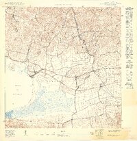
1949 Map of Puerto Real SE
USGS Topo · Published 1949About this map
Bahía de Boquerón dominates the southwestern coastline of Cabo Rojo on this 1949 edition, showcasing the intricate relationship between the Caribbean Sea and the inland salt flats and lagoons. The expansive Laguna Rincón sits as a central water feature, buffered by the Valle de Lajas and the hills of Sierra Bermeja. This preliminary survey by the Gobierno de Puerto Rico reveals a landscape defined by agricultural divisions across Pedernales and Llanos Tuna, where small settlements like Cuatro Caminos and Las Arenas cluster at the crossroads of early transport routes. The transition from the coastal Salinas to the northern hills of Cerro Algodón is marked by numerous seasonal streams such as Quebrada Zumbón, illustrating the region's natural drainage before significant modern urbanization changed the character of these rural barrios.
Find a feature on this map
21 named features on this map. Tap any name to fly to it.
Don’t see what you’re looking for? This feature index may not catch every label — zoom into the map to look around manually.
Map Details
Editions of this 1949 Puerto Real SE Map
This is the sole edition of this map. No revisions or reprints were ever made.
Other maps of this area

1935 · Puerto Real
USGS Topo · 1:25,000

1937 · San German
USGS Topo · 1:25,000

1937 · Puerto Real
USGS Topo · 1:25,000

1938 · Parguera
USGS Topo · 1:30,000

1938 · Cabo Rojo
USGS Topo · 1:30,000

1941 · San German
USGS Topo · 1:30,000

1941 · Puerto Real
USGS Topo · 1:30,000
1949 · Cabo Rojo NE
USGS Topo · 1:10,000
1949 · Puerto Real NE
USGS Topo · 1:10,000
1949 · Puerto Real SO
USGS Topo · 1:10,000
Featured Places
- El Fuego y Las Piedras, Cabo Rojo
- Boquerón, Cabo Rojo
- Llanos Tuna, Cabo Rojo
- Centro Vacacional de Boquerón, Cabo Rojo
- Terrazas de Boquerón, Cabo Rojo