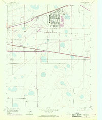
1956 Map of Pullman
USGS Topo · Published 1968About this map
Amarillo Air Force Base dominates the northeastern landscape of this mid-century survey, reflecting the era's Cold War military footprint in the Texas Panhandle. The map reveals a dense network of transportation and communication infrastructure serving the high plains, including a Telegraph Line and an underground Telegraph Cable paralleling the major rail corridors. Rail operations are central to the local economy, with the Atchison Topeka and Santa Fe, the Chicago Rock Island and Pacific, and the Fort Worth and Denver lines all converging in the vicinity of Pullman.
Find a feature on this map
26 named features on this map. Tap any name to fly to it.
Don’t see what you’re looking for? This feature index may not catch every label — zoom into the map to look around manually.
Map Details
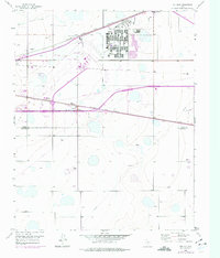
Editions of this 1956 Pullman Map
3 editions found
Other maps of this area

1934 · Cliffside
USGS Topo · 1:62,500

1936 · Cliffside
USGS Topo · 1:62,500

1953 · Pleasant Valley
USGS Topo · 1:24,000

1953 · Mayer
USGS Topo · 1:24,000

1953 · Sevenmile Basin
USGS Topo · 1:24,000

1954 · Amarillo
USGS Topo · 1:250,000

1956 · Amarillo East
USGS Topo · 1:24,000

1956 · Washburn
USGS Topo · 1:24,000

1956 · Thomas Ranch
USGS Topo · 1:24,000

1956 · Pullman
USGS Topo · 1:24,000