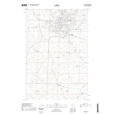
2020 Map of Pullman
USGS Topo · Published 2020About this map
Pullman sits at the confluence of several watercourses, most notably the S Fork Palouse River and Paradise Cr, which weave through the city's complex street grid. The landscape is defined by the sharp transition between the urban center and the surrounding agricultural uplands, characterized by landforms like Cougar Ridge. South of the main settlement, the map traces a network of small rural communities and stopping points that once dotted the Palouse region. Local history and genealogy interest is anchored by landmarks such as the Pullman City Cem and the more remote Farr Cem. The rail influence of the era is evident at Pullman Junction, while the surrounding territory is peppered with hamlets like Johnson, Busby, and Chambers. These smaller locales, often centered on road intersections or rail crossings, reflect the traditional rural settlement patterns of Whitman County.
Find a feature on this map
110 named features on this map. Tap any name to fly to it.
Don’t see what you’re looking for? This feature index may not catch every label — zoom into the map to look around manually.
Map Details
Editions of this 2020 Pullman Map
This is the sole edition of this map. No revisions or reprints were ever made.
Other maps of this area

1910 · Pullman
USGS Topo · 1:125,000

1955 · Pullman
USGS Topo · 1:250,000

1958 · Pullman
USGS Topo · 1:250,000

1964 · Viola
USGS Topo · 1:24,000

1964 · Moscow West
USGS Topo · 1:24,000

1964 · Colton
USGS Topo · 1:24,000
1964 · Albion
USGS Topo · 1:24,000

1964 · Colfax South
USGS Topo · 1:24,000

1964 · Ewartsville
USGS Topo · 1:24,000

1964 · Bishop
USGS Topo · 1:24,000