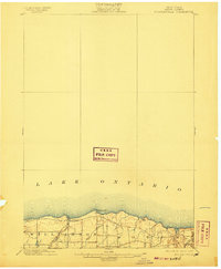
1902 Map of Pultneyville
USGS Topo · Published 1907About this map
The southern shore of Lake Ontario defines this late nineteenth-century landscape, centered on the harbor at Pultneyville. Surveyed in 1898, the topography reveals a rural region in transition between the townships of Williamson and Sodus. Local industry and transit are marked by the presence of the Electric R. R. and the N. C. R. R., which parallel the coastline to the south. The terrain is characterized by gentle undulations and significant drainage basins such as Salmon Creek and Mink Creek, which flow toward the lake. Distinctive landmarks like Fairbanks Pt. and Nigger Hill serve as navigational anchors for this stretch of the Wayne County shoreline during an era when maritime commerce and emerging rail networks intersected at the water's edge.
Find a feature on this map
9 named features on this map. Tap any name to fly to it.
Don’t see what you’re looking for? This feature index may not catch every label — zoom into the map to look around manually.
Map Details
Editions of this 1902 Pultneyville Map
5 editions found
Other maps of this area

1899 · Palmyra
USGS Topo · 1:62,500

1900 · Macedon
USGS Topo · 1:62,500

1902 · Sodus Bay
USGS Topo · 1:62,500

1902 · Pultneyville
USGS Topo · 1:62,500

1902 · Clyde
USGS Topo · 1:62,500

1902 · Palmyra
USGS Topo · 1:62,500

1942 · Ontario
USGS Topo · 1:31,680

1942 · Pultneyville
USGS Topo · 1:31,680

1943 · Williamson
USGS Topo · 1:31,680

1943 · Sodus Point
USGS Topo · 1:31,680