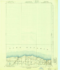
1902 Map of Pultneyville
USGS Topo · Published 1939About this map
Pultneyville sits prominently along the southern shoreline of Lake Ontario, serving as a focal point for this late nineteenth-century survey of Wayne County. The landscape is defined by the agricultural and transit corridor between the townships of Williamson and Sodus. A burgeoning transportation network is evident through the parallel routes of the N. Y. C. R. R. and the Electric R. R., which cut across the coastal plain. These rail lines, combined with drainage from Salmon Creek and Mink Creek, illustrate a period of transition where maritime access met modern industrial rail. Inland terrain rises toward landmarks like Nigger Hill, while the coast is marked by the distinct projection of Fairbanks Pt., reflecting the era's reliance on both land-based transit and the lake's edge for commerce.
Find a feature on this map
9 named features on this map. Tap any name to fly to it.
Don’t see what you’re looking for? This feature index may not catch every label — zoom into the map to look around manually.
Map Details
Editions of this 1902 Pultneyville Map
5 editions found
Other maps of this area

1899 · Palmyra
USGS Topo · 1:62,500

1900 · Macedon
USGS Topo · 1:62,500

1902 · Sodus Bay
USGS Topo · 1:62,500

1902 · Pultneyville
USGS Topo · 1:62,500

1902 · Clyde
USGS Topo · 1:62,500

1902 · Palmyra
USGS Topo · 1:62,500

1942 · Ontario
USGS Topo · 1:31,680

1942 · Pultneyville
USGS Topo · 1:31,680

1943 · Williamson
USGS Topo · 1:31,680

1943 · Sodus Point
USGS Topo · 1:31,680