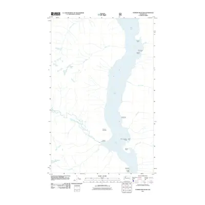
2011 Map of Pumpkin Mountain
USGS Topo · Published 2011About this map
Ross Lake dominates this 2011 survey, cutting through the high country of Whatcom County where several islands and points define the shoreline. The geography is characterized by the massive presence of Pumpkin Mountain, which rises between the drainage of Big Beaver Creek and the lake itself. A network of backcountry access points and campsites, including Big Bear Campground and Spencer Camp, suggests the area's role as a major recreational corridor within the North Cascades. High-elevation water bodies like Skymo Lake and Noname Lake feed a complex system of tributaries, such as Skymo Creek and Noname Creek, that flow toward the central basin. The presence of Little Jerusalem Island and Tenmile Island highlights the intricate lake topography created by the valley's inundation, providing a precise record of the shoreline and its associated camps like Rainbow Point Campground and Cougar Island Campground during the early 21st century.
Find a feature on this map
23 named features on this map. Tap any name to fly to it.
Don’t see what you’re looking for? This feature index may not catch every label — zoom into the map to look around manually.
Map Details
Editions of this 2011 Pumpkin Mountain Map
This is the sole edition of this map. No revisions or reprints were ever made.
Other maps of this area

1920 · Slate Pass
USGS Topo · 1:125,000

1955 · Concrete
USGS Topo · 1:250,000

1958 · Concrete
USGS Topo · 1:250,000

1962 · Concrete
USGS Topo · 1:250,000

1963 · Crater Mountain
USGS Topo · 1:24,000

1963 · Diablo Dam
USGS Topo · 1:24,000

1963 · Ross Dam
USGS Topo · 1:24,000

1969 · Skagit Peak
USGS Topo · 1:24,000

1969 · Mt Prophet
USGS Topo · 1:24,000
1969 · Jack Mtn
USGS Topo · 1:24,000