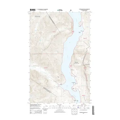
2014 Map of Pumpkin Mountain
USGS Topo · Published 2014About this map
Ross Lake dominates this 2014 survey, carving a deep blue corridor through the high elevations of the North Cascades National Park and the Ross Lake National Recreation Area. The landscape is defined by its dramatic verticality, where Pumpkin Mtn and Roland Point rise sharply above the water. A network of remote backcountry infrastructure is visible, including the Pacific NW National Scenic Trail which winds across the western and eastern slopes. This era of the park's management is marked by numerous water-access sites such as Rainbow Point Campground, Tenmile Island Campground, and Big Bear Campground. To the east, the boundary of the Mount Baker National Forest meets the recreation area, while isolated alpine features like Skymo Lake and Sourdough Lake occupy high basins fed by numerous drainages including Big Beaver Creek and Devils Cr.
Find a feature on this map
33 named features on this map. Tap any name to fly to it.
Don’t see what you’re looking for? This feature index may not catch every label — zoom into the map to look around manually.
Map Details
Editions of this 2014 Pumpkin Mountain Map
This is the sole edition of this map. No revisions or reprints were ever made.
Other maps of this area

1920 · Slate Pass
USGS Topo · 1:125,000

1955 · Concrete
USGS Topo · 1:250,000

1958 · Concrete
USGS Topo · 1:250,000

1962 · Concrete
USGS Topo · 1:250,000

1963 · Crater Mountain
USGS Topo · 1:24,000

1963 · Diablo Dam
USGS Topo · 1:24,000

1963 · Ross Dam
USGS Topo · 1:24,000

1969 · Skagit Peak
USGS Topo · 1:24,000

1969 · Mt Prophet
USGS Topo · 1:24,000
1969 · Jack Mtn
USGS Topo · 1:24,000