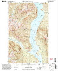
2002 Map of Pumpkin Mountain
USGS Topo · Published 2006About this map
Pumpkin Mountain stands as a central topographic anchor in this rugged corridor of the Pacific Northwest, where the Ross Lake reservoir divides the landscape. This 2002 revision shows the sophisticated network of backcountry management within the North Cascades National Park and the Ross Lake National Recreation Area. The map details a specialized infrastructure for wilderness travel, distinguishing between stock-accessible sites like Lightning Creek (Stock Camp) and water-access points such as Devils Creek (Boat Camp).
Find a feature on this map
40 named features on this map. Tap any name to fly to it.
Don’t see what you’re looking for? This feature index may not catch every label — zoom into the map to look around manually.
Map Details
Editions of this 2002 Pumpkin Mountain Map
This is the sole edition of this map. No revisions or reprints were ever made.
Other maps of this area

1920 · Slate Pass
USGS Topo · 1:125,000

1955 · Concrete
USGS Topo · 1:250,000

1958 · Concrete
USGS Topo · 1:250,000

1962 · Concrete
USGS Topo · 1:250,000

1963 · Crater Mountain
USGS Topo · 1:24,000

1963 · Diablo Dam
USGS Topo · 1:24,000

1963 · Ross Dam
USGS Topo · 1:24,000

1969 · Skagit Peak
USGS Topo · 1:24,000

1969 · Mt Prophet
USGS Topo · 1:24,000
1969 · Jack Mtn
USGS Topo · 1:24,000