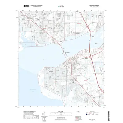
2018 Map of Punta Gorda
USGS Topo · Published 2018About this map
The Peace River dominates this coastal landscape as it flows into Charlotte Harbor, separating the growing residential developments of Port Charlotte from the historic street grid of Punta Gorda. The transition from the mid-twentieth-century canal systems of Punta Gorda Isles and Morningstar Canal to the older settlements like Solana and Acline illustrates the evolution of southwest Florida's waterfront infrastructure. Along the southern bank, the Tamiami Trl serves as the primary artery, crossing the water via the Gilchrist Bridge and Barron Collier Bridge. The map details a complex network of waterways, from the N Fork Alligator Cr to the mangrove-lined shores near Mangrove Point, reflecting the region's deep connection to the Gulf of Mexico.
Find a feature on this map
37 named features on this map. Tap any name to fly to it.
Don’t see what you’re looking for? This feature index may not catch every label — zoom into the map to look around manually.
Map Details
Editions of this 2018 Punta Gorda Map
This is the sole edition of this map. No revisions or reprints were ever made.
Other maps of this area

1956 · Murdock
USGS Topo · 1:24,000

1956 · Murdock SE
USGS Topo · 1:24,000

1956 · Cleveland
USGS Topo · 1:24,000

1956 · Ft. Ogden
USGS Topo · 1:24,000

1956 · Punta Gorda SE
USGS Topo · 1:24,000

1956 · West Palm Beach
USGS Topo · 1:250,000

1956 · Tampa
USGS Topo · 1:250,000

1956 · Fort Pierce
USGS Topo · 1:250,000

1956 · Charlotte Harbor
USGS Topo · 1:250,000

1957 · West Palm Beach
USGS Topo · 1:250,000