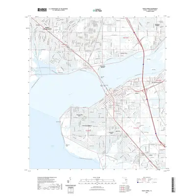
2021 Map of Punta Gorda
USGS Topo · Published 2021About this map
Punta Gorda and Port Charlotte flank the wide mouth of the Peace River in this detailed survey of Charlotte County’s coastal corridor. The map shows a highly developed canal system and waterfront infrastructure, particularly within Punta Gorda Isles and the neighboring community of Solana. Transportation is anchored by the Tamiami Trl, which crosses the river via the Gilchrist Bridge and Barron Collier Bridge, connecting these residential hubs with Charlotte Harbor and Harbor View.
Find a feature on this map
45 named features on this map. Tap any name to fly to it.
Don’t see what you’re looking for? This feature index may not catch every label — zoom into the map to look around manually.
Map Details
Editions of this 2021 Punta Gorda Map
This is the sole edition of this map. No revisions or reprints were ever made.
Other maps of this area
1956 · Murdock
USGS Topo · 1:24,000
1956 · Murdock SE
USGS Topo · 1:24,000
1956 · Cleveland
USGS Topo · 1:24,000
1956 · Ft. Ogden
USGS Topo · 1:24,000
1956 · Punta Gorda SE
USGS Topo · 1:24,000

1956 · West Palm Beach
USGS Topo · 1:250,000

1956 · Tampa
USGS Topo · 1:250,000
1956 · Fort Pierce
USGS Topo · 1:250,000
1956 · Charlotte Harbor
USGS Topo · 1:250,000

1957 · West Palm Beach
USGS Topo · 1:250,000