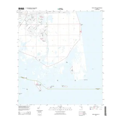
2015 Map of Punta Gorda SW
USGS Topo · Published 2015About this map
Mound Key, Cash Mound, and John Quiet Mound stand as significant cultural landmarks along the intricate coastline of Charlotte Harbor. This coastal landscape is defined by a dense network of tidal keys and estuaries, including Cayo Pelau and Little Cape Haze at the southern end. To the north, residential development is clustered around Coral Creek Airport, with street names like Bluebird Dr and Cardinal Dr reflecting the local environment. The geography is dominated by water features such as Gasparilla Sound and the Intracoastal Waterway, which navigate through a complex archipelago of islands like Sandfly Key and Devilfish Key. The boundary between Charlotte County and Lee County cuts through these waters, marking a transition between the northern residential developments and the more open bay environments of Bull Bay and Cape Haze Bay.
Find a feature on this map
75 named features on this map. Tap any name to fly to it.
Don’t see what you’re looking for? This feature index may not catch every label — zoom into the map to look around manually.
Map Details
Editions of this 2015 Punta Gorda SW Map
This is the sole edition of this map. No revisions or reprints were ever made.
Other maps of this area

1956 · Punta Gorda SE
USGS Topo · 1:24,000

1956 · Englewood
USGS Topo · 1:24,000

1956 · Tampa
USGS Topo · 1:250,000

1956 · Charlotte Harbor
USGS Topo · 1:250,000

1957 · El Jobean
USGS Topo · 1:24,000

1957 · Punta Gorda SW
USGS Topo · 1:24,000

1957 · Punta Gorda
USGS Topo · 1:24,000

1957 · Placida
USGS Topo · 1:24,000

1958 · Matlacha
USGS Topo · 1:24,000

1958 · Port Boca Grande
USGS Topo · 1:24,000