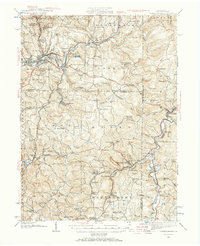
1939 Map of Punxsutawney
USGS Topo · Published 1965About this map
The Mahoning Creek watershed and the upper reaches of the Susquehanna River define this rural landscape during the late 1930s. The regional economy is anchored by the borough of Punxsutawney, where the Baltimore and Ohio and Pennsylvania railroads converge. This map reveals a high density of rural infrastructure, particularly the numerous township schools like Harmony Thomas Sch, Wainwright Sch, and Couch Sch, which illustrate the community-centric organization of the era. Settlement patterns follow the creek valleys and rail spurs, connecting mining and agricultural hubs such as Rossiter, Glen Campbell, and Burnside.
Find a feature on this map
153 named features on this map. Tap any name to fly to it.
Don’t see what you’re looking for? This feature index may not catch every label — zoom into the map to look around manually.
Map Details
Editions of this 1939 Punxsutawney Map
2 editions found

Other maps of this area

1902 · Indiana
USGS Topo · 1:62,500

1902 · Patton
USGS Topo · 1:62,500

1902 · Barnesboro
USGS Topo · 1:62,500

1903 · Curwensville
USGS Topo · 1:62,500

1904 · Barnesboro
USGS Topo · 1:62,500

1904 · Patton
USGS Topo · 1:62,500

1906 · Punxsutawney
USGS Topo · 1:62,500

1909 · Smicksburg
USGS Topo · 1:62,500

1922 · Du Bois
USGS Topo · 1:62,500

1924 · Du Bois
USGS Topo · 1:62,500