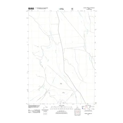
2011 Map of Purcell Spring
USGS Topo · Published 2011About this map
Texas Creek and Eighteenmile Creek define the drainage of this Lemhi County landscape, where water sources were critical for high-desert navigation and cattle ranching. The map shows a network of vital watering points including Cold Spring, Purcell Spring, and Nez Perce Spring, which served as anchors for early movement through the region. This terrain is marked by significant topographical features such as Big Dry Gulch and Little Dry Gulch, indicating a seasonally arid environment. Forest Service access is preserved through routes like Nat For Dev Rd 212, while older paths like the NFO 212 Trl trace established corridors between the peaks and the valley floors. These springs and named creeks like Negro Green Creek highlight the specific locations where surveyors and early inhabitants found reliable water in a landscape of intermittent flows.
Find a feature on this map
19 named features on this map. Tap any name to fly to it.
Don’t see what you’re looking for? This feature index may not catch every label — zoom into the map to look around manually.
Map Details
Editions of this 2011 Purcell Spring Map
This is the sole edition of this map. No revisions or reprints were ever made.
Other maps of this area

1955 · Dubois
USGS Topo · 1:250,000

1956 · Leadore
USGS Topo · 1:62,500

1956 · Morrison Lake
USGS Topo · 1:62,500

1956 · Nicholia
USGS Topo · 1:62,500

1957 · Gilmore
USGS Topo · 1:62,500

1958 · Dubois
USGS Topo · 1:250,000

1980 · Leadore
USGS Topo · 1:100,000

1987 · Gilmore
USGS Topo · 1:24,000
1987 · West of Leadore
USGS Topo · 1:24,000

1987 · Purcell Spring
USGS Topo · 1:24,000