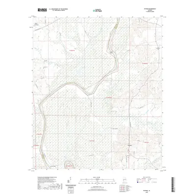
2020 Map of Putnam
USGS Topo · Published 2020About this map
Putnam sits at the intersection of AL Highway 69 and Marengo Co 41, serving as a central point in this rural landscape of southwestern Alabama. The terrain is defined by the winding course of Cotahoma Creek and Sucarnochee Cr, which meander through heavily wooded sections and wetlands. To the northwest, the Butler-Choctaw County Airport provides a modern aviation link near the county line, while the historical character of the area is preserved in numerous family and community burial grounds, such as White Cem, Spencer Cem, and Putnam Cem. Further east, the Mount Mariah Cem overlooks the drainage of Sweetwater Cr. The map details the transition from the upland ridges down to the alluvial bottoms of Pearsons Shoal and the wide arc of Jacksons Bend, illustrating a settlement pattern deeply tied to the local watercourses and the traditional land divisions of the Public Land Survey System.
Find a feature on this map
46 named features on this map. Tap any name to fly to it.
Don’t see what you’re looking for? This feature index may not catch every label — zoom into the map to look around manually.
Map Details
Editions of this 2020 Putnam Map
This is the sole edition of this map. No revisions or reprints were ever made.
Other maps of this area

1953 · Montgomery
USGS Topo · 1:250,000

1953 · Andalusia
USGS Topo · 1:250,000

1953 · Hattiesburg
USGS Topo · 1:250,000

1953 · Meridian
USGS Topo · 1:250,000

1956 · Montgomery
USGS Topo · 1:250,000

1957 · Meridian
USGS Topo · 1:250,000

1957 · Montgomery
USGS Topo · 1:250,000

1957 · Andalusia
USGS Topo · 1:250,000

1958 · Hattiesburg
USGS Topo · 1:250,000

1965 · Meridian
USGS Topo · 1:250,000