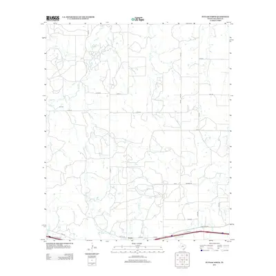
2012 Map of Putnam North
USGS Topo · Published 2012About this map
Putnam occupies the southern edge of this landscape in Callahan County, serving as a focal point for a network of rural roads that extend northward into the ranching and agricultural country of West Texas. The terrain is defined by a dense web of ephemeral waterways including Post Oak Cr, Live Oak Cr, and Battle Cr, which suggest a seasonal pulse of water through the region. Significant for local historians and genealogists, the Hart Cem is located in the western portion of the map, situated near the headwaters of Sheep Cr. The infrastructure of the early 21st century is visible in the alignment of Ranch Road 2945 and the I 20 Access Rd, which parallel the southern boundary. This survey provides a clear view of the land parcels and property boundaries defined by numerous county roads like Co Rd-319 and Co Rd-311.
Find a feature on this map
33 named features on this map. Tap any name to fly to it.
Don’t see what you’re looking for? This feature index may not catch every label — zoom into the map to look around manually.
Map Details
Editions of this 2012 Putnam North Map
This is the sole edition of this map. No revisions or reprints were ever made.
Other maps of this area

1892 · Albany
USGS Topo · 1:125,000

1893 · Albany
USGS Topo · 1:125,000

1931 · Baird
USGS Topo · 1:125,000

1932 · Baird
USGS Topo · 1:125,000

1954 · Abilene
USGS Topo · 1:250,000

1958 · Abilene
USGS Topo · 1:250,000
1965 · Snyder Lake
USGS Topo · 1:24,000

1965 · Indian Knoll
USGS Topo · 1:24,000
1965 · Moran
USGS Topo · 1:24,000

1966 · Scranton
USGS Topo · 1:24,000